
Remote Sensing for Geospatial Intelligence
Cutting-Edge Earth Observation Solutions
Earth observation data from remote sensing satellites is becoming increasingly vital for decision-makers, driven by advances in sensor technology, machine learning, and improved accessibility. ThirdEye GeoAnalytics delivers cutting-edge remote sensing solutions that enhance geospatial intelligence and enable real-time or near real-time spatial data integration across key sectors.
info@thirdeyegeoanalytics.comActionable Earth Observation Intelligence
Using satellite imagery, drone data, and sensor platforms, we provide scalable, analysis-ready outputs that strengthen GIS workflows and support fast, evidence-based decisions.
Real-Time Decision Support
We deliver actionable Earth observation data to frontline responders; empowering rapid, informed decision-making in high-stakes situations.
Our advanced remote sensing capabilities transform raw satellite and UAV data into meaningful intelligence that drives strategic decision-making across multiple sectors and applications.
Through cutting-edge processing techniques and machine learning algorithms, we ensure that complex geospatial data becomes accessible and actionable for organizations of all sizes.
Domain-Specific Applications
Specialized remote sensing solutions tailored to meet the unique requirements of different sectors and use cases
Public Health
We apply remote sensing and geospatial analytics to:
- Map environmental exposures and support spatial epidemiology
- Classify settlements and assess population distribution
- Analyze health facility catchment areas
- Monitor public health infrastructure using multispectral and high-resolution imagery
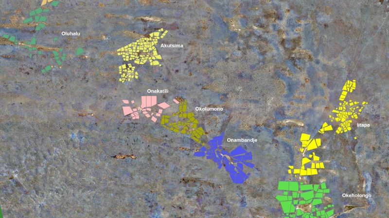
Cadastral Mapping
We support land administration systems with:
- High-accuracy parcel boundary extraction using orthorectified satellite and UAV imagery
- Spatial verification of claims and field-based validation
- Multi-temporal image analysis for land adjudication and registration
- Seamless integration with cadastral databases to enhance accuracy, transparency, and governance
Finance and Risk Analysis
We empower financial institutions and insurers through:
- Asset and infrastructure monitoring
- Climate and environmental risk modelling
- Index-based insurance mapping and zone delineation
- Geospatial credit risk profiling by fusing remote sensing with financial data layers
Core Capabilities
Multi-Platform Image Processing
Processing of optical, multispectral, SAR, and UAV imagery for analysis-ready outputs
Advanced Feature Extraction
Automated feature extraction and object-based image analysis (OBIA)
Enterprise Integration
Integration of remote sensing outputs into enterprise GIS and real-time decision platforms
Field Validation Tools
Deployment of mobile data collection tools for field validation and ongoing monitoring